ESTIMATION OF SHORELINE CHANGES OF THE CAI RIVER
ESTUARY IN VIET NAM
THANH LUAN NGUYEN1*), THANH TUNG TRAN2), HOANG SON NGUYEN3),
VAN VAN THAN4) and YVES LACROIX5)
VAN VAN THAN4) and YVES LACROIX5)
1*) Vietnam Key Laboratory of River and Coastal Engineering (KLORCE)
within Vietnam Academy for Water Resources (VAWR)
No 1, 165 Lane, Chua Boc - Dong Da, Ha Noi, Viet Nam
corresponding author to provide phone: +84(43)8521624; e-mail: thanhluance@gmail.com
2) Faculty of Marine and Coastal Engineering, TLU, Hanoi, Vietnam
175 Tay Son, Dong Da, Ha Noi, Viet Nam
e-mail: tunghwru@gmail.com
3) Faculty of Hydrology and Water Resources, TLU, Hanoi, Vietnam
175 Tay Son, Dong Da, Ha Noi, Viet Nam
e-mail: hoangson38v@gmail.com
4) Laboratory LATP, AMU and Faculty of Civil Engineering, TLU, Hanoi, Vietnam
39, rue F. Joliot Curie, 13453 Marseille Cedex 13, France
e-mail: thanvanvan@tlu.edu.vn
5) SEATECH, UTLN and MEMOCS, Università Degli Studi dell’Aquila, Italy
avenue G. Pompidou, 83162 La Valette du Var, France
e-mail: yves.lacroix@univ-tln.fr
Abstract
The Nha Trang Bay is one of the 29th most beautiful bays in
the world, has been the centre of tourism and service of the Khanh Hoa province
with quick growth in particular and the South Central region of Vietnam in
general. Beside the development of infrastructure, urban, activities of people,
impact of climate change, etc.,… they have made estuaries and coastal evolution
more complicated. This paper presents accretion, erosion patterns at estuaries
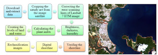
and coastal of Nha Trang bay by space and time scale with remote sensing
technology and GIS. With a series of Landsat from 1999 to 2013, we give
analysis results to calculate specifically shoreline changes. The sand dunes of
the Northern and Southern coasts fluctuate, causing the expansion or the contraction
of the width of the estuary. The study results showed that the Northern sand dune
is tending to erode; the Southern one presents alternating periods of erosion
and deposition that are seasonal, reported in recent years. The study results
are the basis for scientist, administrator to find out surmounted methods,
orienting coastal protection strategy, master plan Nha Trang coastal structure
as Khanh Hoa province.
Keywords: DSAS, remote sensing, Nha Trang
bay, estuary, erosion, accretion.
1. INTRODUCTION
Nha Trang beach stretches from Bai Tien to the Lo river with a
coastline (including the islands) at least 103 km from the Hon Dung island. Hon
Lon island (Hon Tre) is the largest island, located on the eastern bay (Fig.
1).
Southeastern bay is some small scattered islands forming the eastern and
southeastern belt breakwater (a total of 19 islands). This bay has a length of about16
km (parallel along the shore) and width approximately 13 km (perpendicular to
the shore). It has two estuaries: a main northeastern estuary and a smaller
southeast estuary. The main source of freshwater flowing into the bay comes
from the Cai river in Nha Trang. Dinh river (Ninh Hoa) impacts only in the Nha
Phu lagoon; Tac river effects just south of the bay (Bui, 2002).
Determining the cause of coastal evolution (erosion and
deposition) are very important for both scientific research as well as in
practice. However, this is a very complex problem concerning many fields of
study, even different concepts. For fully assessing the dynamics in the estuary
coast of Nha Trang Bay, it is necessary to have an in-depth study with the
appropriate research methodology and long enough period of time. Within the
scope of this paper, the authors use the method of remote sensing image
analysis over the multiple years, with parameters set as seasonal error, tidal
fluctuation error, digitizing error, pixel error, and rectification error (Fletcher et al., 2011; Romine & Fletcher, 2012).
The shoreline changes were assessed by using DSAS tools (Thieler et al., 2009).
Details see full paper at here
Vietnam-Japan
Workshop on Estuaries, Coasts and Rivers 2015
September 7nd
-8rd, Hoi An, Vietnam


0 comments: