ESTIMATION OF SHORELINE CHANGES OF THE CAI RIVER ESTUARY IN VIET NAM

0 comments

               ESTIMATION OF SHORELINE CHANGES OF THE CAI RIVER ESTUARY IN VIET NAM


THANH LUAN NGUYEN1*), THANH TUNG TRAN2), HOANG SON NGUYEN3),
VAN VAN THAN4) and YVES LACROIX5)

1*) Vietnam Key Laboratory of River and Coastal Engineering (KLORCE)
within Vietnam Academy for Water Resources (VAWR)
No 1, 165 Lane, Chua Boc - Dong Da, Ha Noi, Viet Nam
corresponding author to provide phone: +84(43)8521624; e-mail: thanhluance@gmail.com
2) Faculty of Marine and Coastal Engineering, TLU, Hanoi, Vietnam
175 Tay Son, Dong Da, Ha Noi, Viet Nam
e-mail: tunghwru@gmail.com
3) Faculty of Hydrology and Water Resources, TLU, Hanoi, Vietnam
175 Tay Son, Dong Da, Ha Noi, Viet Nam
e-mail: hoangson38v@gmail.com
4) Laboratory LATP, AMU and Faculty of Civil Engineering, TLU, Hanoi, Vietnam
39, rue F. Joliot Curie, 13453 Marseille Cedex 13, France
e-mail: thanvanvan@tlu.edu.vn
5) SEATECH, UTLN and MEMOCS, Università Degli Studi dell’Aquila, Italy
avenue G. Pompidou, 83162 La Valette du Var, France
e-mail: yves.lacroix@univ-tln.fr

Abstract

The Nha Trang Bay is one of the 29th most beautiful bays in the world, has been the centre of tourism and service of the Khanh Hoa province with quick growth in particular and the South Central region of Vietnam in general. Beside the development of infrastructure, urban, activities of people, impact of climate change, etc.,… they have made estuaries and coastal evolution more complicated. This paper presents accretion, erosion patterns at estuaries and coastal of Nha Trang bay by space and time scale with remote sensing technology and GIS. With a series of Landsat from 1999 to 2013, we give analysis results to calculate specifically shoreline changes. The sand dunes of the Northern and Southern coasts fluctuate, causing the expansion or the contraction of the width of the estuary. The study results showed that the Northern sand dune is tending to erode; the Southern one presents alternating periods of erosion and deposition that are seasonal, reported in recent years. The study results are the basis for scientist, administrator to find out surmounted methods, orienting coastal protection strategy, master plan Nha Trang coastal structure as Khanh Hoa province.

Keywords: DSAS, remote sensing, Nha Trang bay, estuary, erosion, accretion.

1.    INTRODUCTION

Nha Trang beach stretches from Bai Tien to the Lo river with a coastline (including the islands) at least 103 km from the Hon Dung island. Hon Lon island (Hon Tre) is the largest island, located on the eastern bay (Fig. 1). Southeastern bay is some small scattered islands forming the eastern and southeastern belt breakwater (a total of 19 islands). This bay has a length of about16 km (parallel along the shore) and width approximately 13 km (perpendicular to the shore). It has two estuaries: a main northeastern estuary and a smaller southeast estuary. The main source of freshwater flowing into the bay comes from the Cai river in Nha Trang. Dinh river (Ninh Hoa) impacts only in the Nha Phu lagoon; Tac river effects just south of the bay (Bui, 2002).
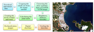
Determining the cause of coastal evolution (erosion and deposition) are very important for both scientific research as well as in practice. However, this is a very complex problem concerning many fields of study, even different concepts. For fully assessing the dynamics in the estuary coast of Nha Trang Bay, it is necessary to have an in-depth study with the appropriate research methodology and long enough period of time. Within the scope of this paper, the authors use the method of remote sensing image analysis over the multiple years, with parameters set as seasonal error, tidal fluctuation error, digitizing error, pixel error, and rectification error (Fletcher et al., 2011; Romine & Fletcher, 2012). The shoreline changes were assessed by using DSAS tools (Thieler et al., 2009).


Details see full paper at here


Vietnam-Japan Workshop on Estuaries, Coasts and Rivers 2015
September 7nd -8rd, Hoi An, Vietnam

Sand overexploitation, deforestation worsen coastal erosion: expert

0 comments
The sea encroaches 30 to 50 metres in the Cua Dai ward annually (Photo: VNA)

The overexploitation of sand, deforestation and natural disasters have led to increasingly serious erosion in many coastal areas of Vietnam, an expert has said. 

Deputy Director of the Vietnam Institute for Water Resources Research Tran Dinh Hoa pointed out the fact at a workshop in central Quang Nam province on September 7. 

Participants at the function, numbering around 200 specialists, said in Quang Nam alone, the simultaneous erosion and soil and sand settlement in the area of the Cua Dai Sea have worsened in recent years, greatly affecting the local socio-economic situation. 

Hoi An is home to 7 kilometres of coastline; in recent years, the sea has encroached 30 to 50 metres in the Cua Dai ward. 

Vice Chairman of the Japan Society of Civil Engineers Hitoshi Tanaka said the possible cause of the severe erosion in this area is the decrease in the volume of mud and sand flowing from the upper Thu Bon River system. 

Experts said a number of localities in Vietnam have yet to design master plans on the exploitation and potential development of and disaster prevention along their estuaries and coasts. Meanwhile, structural measures have not been carried out synchronously, reinforcing certain areas but causing erosion in others. 

Vice Chairman of the Quang Nam People’s Committee Le Tri Thanh said besides temporary measures, the province is working with central agencies and foreign researching bodies to devise long-term solutions, noting that it is examining the exploitation of sand along the Thu Bon River system. 

The workshop was held by Japan’s Tohoku University, the Vietnam Institute for Water Resources Research and Vietnam’s Thuy Loi (Water Resources) University.-VNA

This is climate change: Alaskan villagers struggle as island is chewed up by the sea

0 comments

 Kivalina
 Kivalina, Alaska, in 2007. The barrier reef Kivalina calls home gets smaller and smaller with every storm. (Don Bartletti / Los Angeles Times)
This is what climate change looks like, up close and personal.
In this town of 403 residents 83 miles above the Arctic Circle, beaches are disappearing, ice is melting, temperatures are rising, and the barrier reef Kivalina calls home gets smaller and smaller with every storm.
There is no space left to build homes for the living. The dead are now flown to the mainland so the ocean won't encroach upon their graves. Most here agree that the town should be relocated; where, when and who will pay for it are the big questions. The Army Corps of Engineers figures Kivalina will be underwater in the next decade or so.
Because the town's days on the edge of the Chukchi Sea are numbered, no money has been invested to improve residents' lives. Eighty percent of the homes do not have toilets. Most rely on homemade honey buckets — a receptacle lined with a garbage bag topped by a toilet seat.
Kivalina
One of Kivalina's main roads. The tiny village of 403 residents on the Chukchi Sea lies 83 miles above the Arctic Circle. (Maria La Ganga / Los Angeles Times)
Residents haul water from tanks in the middle of town, 25 cents for five gallons. The school is overcrowded. Still, the unpaved streets here ring with the laughter of children, the buzz of all-terrain vehicles, the whoosh of the wind.
Earlier this summer, White House advance staff cased the slender, apostrophe-shaped island to see whether President Obama could get here during his visit to the Arctic this week — the first by a sitting White House occupant. At the very least, he is scheduled to visit Kotzebue, less than 100 miles away, the heart of Alaska's Northwest Arctic Borough.
Obama has high hopes for addressing climate change during his remaining time in office. The Alaska trip is part of a global warming tour. In Washington he will talk environmental issues with Pope Francis in late September, and in Paris he will attend the United Nations Climate Change Conference in November.
The Alaska trip is part of an effort to "speak openly, honestly and frequently about how climate change is already affecting the lives of Americans and the strength and health of our economy," senior White House advisor Brian Deese said.
Alaskans, Obama said Saturday in his weekly address, are already living with climate change's effects: "More frequent and extensive wildfires. Bigger storm surges as sea ice melts faster. Some of the swiftest shoreline erosion in the world — in some places, more than 3 feet a year.
"Alaska's glaciers are melting faster too," he said, "threatening tourism and adding to rising seas. And if we do nothing, Alaskan temperatures are projected to rise between six and 12 degrees by the end of the century, changing all sorts of industries forever."
Millie Hawley in Kivalina
Millie Hawley, Kivalina tribal president, in front of the sea wall that village residents hope can protect them from the Chukchi Sea until plans are made to relocate. (Maria La Ganga / Los Angeles Times)
Although Obama views this state as the U.S. poster child for climate change, some Alaskans beg to differ. They are glad the president agreed to allow limited offshore oil exploration. They want more access to the vast state's natural resources. And they are wary of a leader who views their home as a global warming disaster area.
Gov. Bill Walker, who will meet with Obama during his visit to the Last Frontier, said he wants the president to support a natural gas pipeline and allow drilling in the Arctic National Wildlife Refuge.
But most of all, the independent governor said in a news conference Tuesday, he doesn't want the Lower 48 to achieve its environmental goals on the backs of Alaskans by barring access to natural resources.
"We probably have the smallest footprint per capita in the nation, if not the world, on impacting climate change," Walker said. "We have some impacts, there's no question, but ... I'm going to talk a lot about the economic climate change that we're experiencing today. That's really what my focus is going to be on with the president."
Shelby Adams has a different message for Obama. That is, if she gets to talk to him when he travels more than 3,600 miles from the Beltway to see the Arctic with his own eyes. Shelby, who just turned 13, has lived in Kivalina her entire life, and she loves her island home dearly.
"It's where I grew up, where everybody I know is," she said five days before Obama was scheduled to land in Kotzebue. "We need to relocate because the ocean is slowly eating away our island."
Shelby was in fourth grade when much of Kivalina was forced to evacuate during a fierce storm in 2011. She and her family were on one of the few planes that made it to the mainland before flying conditions became too dangerous. Everyone else sheltered in the school, the highest point on the nearly flat island.
"We had people sleeping in all the classrooms and the gym," said Emma Knowles, who was Shelby's teacher at McQueen School that year. "Someone had gotten a caribou the day before, so we made a huge pot of caribou stew.... The school didn't even budge. As dilapidated as it looks, it survived."
Kivalina is no stranger to harsh weather, and erosion worries have dogged the 27-acre town almost since its inception in 1905. In the 21st century, however, warming temperatures and the perilous changes that cascade from them have stripped the island of its major source of protection: ice.
Normally each fall, ice begins hugging the Kivalina shoreline around the end of October and stays until the end of June. Even during fierce storms, ice keeps the raging ocean away. But climate change has caused the ice to appear later and melt earlier, leaving the barrier island more vulnerable to storm surges.
Thinner ice also makes it harder for the Inupiat to go whaling. Normally, crews will build camps at the edge of the so-called shore-fast ice and hunt bowhead and beluga whales as they swim north in spring.
"If the shore-fast ice is thin and weak, it's not safe to make a camp," said Timothy Schuerch, president of the Maniilaq Assn., a tribally operated health services organization with clinics in Kivalina and the other borough villages. "Whaling crews have drifted out to sea."
The Inupiat who live in Kivalina get most of their food from the land and sea around them. The increasingly warm weather means an abundance of cloudberries and low-bush blackberries, said Millie Hawley, Kivalina tribal president, but it also threatens many of the food staples on which Alaska natives here depend.
"With the caribou, usually it's like clockwork," Hawley said. "Every June, we'd hunt. We haven't done that in years. It's unpredictable. We don't know when we'll see them."
Kivalina residents hang the caribou's hindquarters outside of their homes to age. The frozen meat is eaten raw, dipped in seal oil, which is also harvested in June. Trout is eaten the same way. The Inupiat also depend on seal for meat.
"Usually we get 80 to 100 seals for the whole community," Hawley said. "This year, we were looking to get eight. The community now has to go without dried meat and oil."
When their traditional foods become scarce, island residents must depend on the Kivalina Native Store, the only one in town. Kivalina is closer to Russia than it is to Anchorage, and nearly all supplies are shipped here by air. Which accounts for astronomical prices:
A quart of shelf-stable whole milk runs $4.19. A can of Campbell's tomato soup is $2.95. A 5-pound bag of unbleached, all-purpose flour is $8.75. A 25.5-ounce bottle of Bertolli extra virgin olive oil is $23.79.
The store is Kivalina's pride and joy, the newest building in this wind-battered town. The old store burned down in December. Its replacement opened in July. It is big, clean, warm and well-stocked. And it stands out in a town of peeling paint and crowded, threatened structures, most on short stilts to protect from flooding.
The school, attended by 154 students from pre-kindergarten through high school, is so jammed that every available space is used for storage. Hallways, stairwells and classrooms are lined with books and supplies. A working washing machine stands at the end of one hall.
The main drags, Bering and Channel streets, are unpaved, their gravel surfaces deeply rutted from the rain and the ATVs that residents use to get around in summer.
Small houses crowd together; each is home to extended families, some of up to 17 or so. At least two houses, Hawley said, are in imminent danger of tumbling into the water. The cemetery lines Kivalina's slender runway, its crosses visible on takeoff and landing.
Because of erosion, there is almost no room to build, Hawley said, so "we break every state and federal regulation. The airport is supposed to be a mile or a mile and a half from the dump. It's 500 feet away."
The fuel tanks that run the power plant were in danger of falling into the Chukchi Sea, so the town moved them to higher, safer ground. Fifty feet away is a small cluster of housing for teachers, which cozies up right next to the school.
When Hawley is asked why her people don't move — somewhere, anywhere to be safe — she is polite but firm. The land and the water make the Inupiat who they are. If they moved to Kotzebue, they would be visitors.
Moving to Anchorage or Fairbanks, she said, "would be like asking us not to be a people any more."
So what does she want to tell the leader of the free world when she greets him next week — in Kotzebue, if not Kivalina?
"We are American citizens," she said, fast and fierce. "We have as much right as all of America to have access to the resources Washington provides. ... If you are going to provide millions of dollars to stop hunger in Africa, my people are hungry. Stop hunger here."
Twitter: @marialaganga
Times staff writer Michael A. Memoli in Washington contributed to this report.
Following by Los Angeles Times

International Project Tracks Beach Pollution Dynamics

0 comments
Bright pink dye used to mimic movement of contaminants off Imperial Beach and Tijuana
Media Contact: 
Mario Aguilera
  |  Phone: 858-534-3624  |  Email: scrippsnews@ucsd.edu
Map of pink dye release
Project tracks pollution as well as movement of sediment and fish larvae.

In an ambitious binational effort to investigate how pollution and other contaminants travel across and along beach waters, scientists from both sides of the border are leading a novel experiment at Imperial Beach and Coronado (south of San Diego), Calif., and Tijuana, Mexico. The National Science Foundation-funded project includes researchers from UC San Diego’s Scripps Institution of Oceanography, Jacobs School of Engineering, and several Mexican institutions.
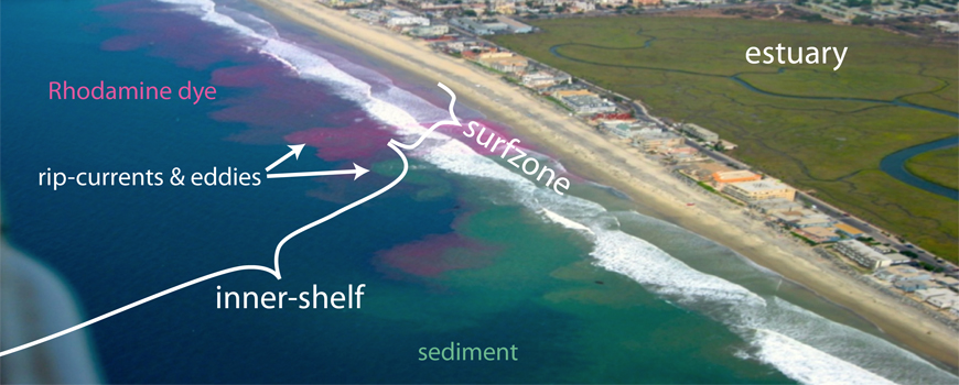
During the Cross Surfzone/Inner-shelf Dye Exchange (CSIDE) project, from Sept. 22 to Oct. 17, researchers will perform three experiments releasing non-toxic bright pink fluorescent dye into beach waters and track its movements along the coast some 10-20 kilometers (6.2-12.4 miles) for nearly 36 hours. One of the dye releases will be at the southern end of Playas de Tijuana, Mexico. A team of scientists, engineers, and technicians will follow the dye with a variety of instruments to obtain a clearer picture of how pollution moves and dilutes along the coast. With this information, study results will eventually be used by managers and policy makers to guide beach closure decisions and evaluate upstream mitigation possibilities.
Coastal waters are valuable natural resources for food, revenue, recreation, and ecosystems. Unhealthy water conditions due to pathogens, human discharge, and other contaminants threaten water quality along the shoreline. Such adverse conditions were exposed in mid-September when San Diego County beaches from the Mexican border to Coronado were closed due to pollutants flooding into the ocean from heavy rain.
“The U.S. population is concentrated at the coasts. Despite the importance of clean coastal waters to our economy and well-being, declining water quality from pollutants, such as sewage, entering the ocean threatens coastal ecosystems and human health,” said Falk Feddersen, a Scripps Oceanography professor and a CSIDE project leader. “By tracking dye released both north and south of the border, we can understand the rate of pollutant transport along the coast, how it dilutes, and learn how to develop accurate models for when it will be okay or not to go in the ocean— similar to weather models.”
The pink dye will be tracked at the shoreline, from boats, and from a Jet ski with an instrument called a fluorometer that measures the dye fluorescence. The dye will also be measured from a plane with a hyperspectral sensor that makes detailed measurements of ocean color. Demonstrating the importance of this study, Naval Base Coronado has given the researchers approval to perform dye sampling work on Navy property between Imperial Beach and Coronado and the waters offshore. Supporters also included the cities of Imperial Beach and Coronado, California state parks, and the National Estuarine Research Reserve System.
“This work applies broadly to coastlines around the world and has local relevance to the water quality problems experienced in the San Diego Bight,” said Sarah Giddings, an assistant professor at Scripps and co-leader of CSIDE. “We have developed a binational team of scientists because coastal water quality is not a national issue. Water currents, waves, and watersheds do not follow borders and thus neither do the things carried by the water. This work applies not just to water quality but to transport of other water-borne constituents such as sediment and fish larvae.”
A research team led by mechanical engineering Professor Geno Pawlak also will be using an autonomous underwater vehicle to map the dye dispersal outside of the surf zone at the coast. The team will specifically examine the structure and evolution of large-scale eddies formed by rip currents. Engineers will combine the vehicle’s measurements with traditional fixed sensors that oceanographers have installed in the area where the dye will be released.
“The hypothesis is that these eddies play an important role in the exchange of water between the nearshore region and the shelf,” said Pawlak, who leads a research group at the Jacobs School of Engineering at UC San Diego. “Their longevity and structure can influence transport to and from the shore of nutrients and biology but also potentially pollutants and pathogens.”
CSIDE builds upon the successes of previous beach pollution studies, including the 2009 Imperial Beach Pollutant Transport and Dilution Experiment. The 2015 project expands the scope of study by tracking dye over longer periods of time and across broader stretches of coastline.
The new project is the latest chapter in a foundation of research by Scripps coastal oceanographers built over decades to more fully understand complex processes along the coast. As one example, the Coastal Data Information Program (CDIP), supported by the U.S. Army Corps of Engineers and the California Division of Boating and Waterways, specializes in wave measurements, wave modeling—including nowcasts and forecasts—and the analysis of coastal environment data. CDIP data are used daily by a vast mix of users, including offshore mariners, harbor masters, coastal managers, and surfers.
CSIDE supporters also include WILDCOASTSurfriderSan Diego Coastkeeper, YMCA Camp Surf, as well as 25 undergraduate researchers.

Following by scripps

Visitors

Flag Counter

About Me

River,Marine and Coastal Engineering
· Coastal and river dynamics; Modeling of waves and currents. . Sediment transport and morphodynamic modeling of rivers, estuaries and coastal zones. · Wave and current actions on structures. · Responses of structures under wave actions. · New technologies in port and coastal structure construction. · Planning, construction and monitoring of coastal zones
View my complete profile
 
Copyright 2010 Marine and Coastal Engineering.
Blogger Template by Noct. Free Download Blogger Template
Powered by Blogger